ROCAS
PROJECT
PROJECT OVERVIEW
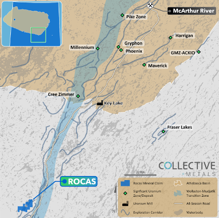
The Rocas project comprises 4,002 hectares, located 75 kilometers southwest of the Key Lake Mine and Mill facilities along Highway 914, and approximately 72 kilometers south of the present-day margin of the Athabasca Basin. The project was acquired via staking in May 2023 and recently expanded by an additional 931 hectares.

PREVIOUS WORK
Additionally, a 2007 field sampling program identified anomalous lakebed geochemical anomalies that statistically rank as greater than 95th percentile U, Co, V, and Zn along the conductor corridor, including high U/Th ratios.
GEOLOGY
The Project covers 7.5 kilometres of a northeast trending magnetic low/electromagnetic (“EM”) conductor corridor which hosts several uranium showings, including historical mineralized outcrop grab samples along approximately 900 metres of strike length, grading up to 0.5 wt.% U3O81. Notably, none of the historical uranium occurrences have been drill-tested.

EXPLORATION PLANS
-
The Standard Uranium exploration team mobilized to the Project on September 30th, 2025, to undertake a detailed mapping, prospecting, and sampling program to ground-truth historical uranium showings at surface. Collected grab samples will be transported to Saskatchewan Research Council Geoanalytical Laboratories in Saskatoon, SK for geochemical analysis.
-
Multiple new drill target zones have been identified on the Rocas project, outlined via the confluence of low gravity anomalies, historical surface mineralization, lakebed geochemical anomalies, EM conductors, and crosscutting fault zones.
-
Ongoing geophysical interpretation and modeling is planned throughout 2025 to integrate historical results with newly collected datasets, which will provide high-priority drill targets and significantly derisk the Project prior to modern drilling next year.
